To the upper reaches of the Alde - July 1997
Our fleet included the two HSC Wayfarerers together with my John and Josephine's sailing dinghy. These three boats turned out to have very similar speed under the light weather conditions of this trip. Having three boats of similar performance and all with excellent shallow water capability certainly helped us to keep in company at sea and for our overnight stops. Generally if one of us ran aground we all ran aground.
All but two nights we ate in pubs or restaurants, this is much the easiest arrangement with a large party and you get some needed exercise tracking down suitable pubs on foot. We did carry food for breakfast and picnics and a reserve of tinned and dried food for a couple of evening meals should we have to spend the night in some remote spot. We had more camping gas stoves than really necessary, two or three stoves are probably quite sufficient for the simple cooking one is likely to do in this situation. We made a mistake with saucepans in that we took a considerable number of the tiny sauce pans as sold in camping shops whereas for communal cooking just a couple of large pans would be better.
Most of the time we did not sail in close convoy but we tried not to get out of sight of each other and arranged to re-group about twice during each passage. For this trip we experimented for the first time with radio communication between the boats, but this caused more amusement than practical benefit since we took along a couple of ultra cheap radios which only worked over little more than shouting distance and then only with Morse code. Only Mark Smith actually knew Morse code but we did learn the code for ‘T’ for tea time. I am sure that proper radios could be very useful on this kind of trip, indeed they would almost spoil the fun by making it too easy.

Route map
Most cruise logs are deadly boring for the reader unless there are a few scary incidents and preferably the occasional minor disaster. On this cruise very little did go wrong, apart perhaps from a badly chosen camp site at Erwarten. For the record, my day by day account continues as follows:
Saturday:
On the Saturday evening before the start of the cruise we all rendezvoued in the Anchor pub at Canewdon and we then camped the night at Wallasea campsite. This ensured that we were all together and ready to go on the Sunday morning.
Sunday: We made an initially slow start, drifting away from Paglesham. Sid came over from his home in Southend to help us load the boats and see us off. The wind picked up as we sailed out to sea and because it was nearly low tide we avoided Ray Sand Channel and sailed right out to Swin Spitway then set a course to Clacton. We arrived at Walton Stone at high water which avoided the need to go round the shallows out to Pye End buoy.
CLICK HERE for some pictures of the beach at Walton Stone.
That evening we took a walk up over the high headland of the Naze and down into Walton town where Peter found a pleasant Cafe for our evening meal.
Monday: We sailed from Walton across the entrance to Harwich Harbour and then on for lunch at the well known cafe at Felixtowe Ferry at the entrance to the Deben. A stream of ships exiting Harwich caused a little anxiety and I noticed the crew of Meander taking to the oars as they were becalmed between two ships, the pilot launch coming over to check that they were safe. From Felixtowe Ferry we raced up the Deben with the flood then the clouds burst as we were about to pitch tents by some trees bordering the salting just below Waldringfield. The rain did not last long and we dined that evening in the Maybush pub at Waldringfield.
Tuesday: The ebb carried us back down the Deben to Felixtow Ferry where we again visited the cafe then turned North up the coast to Shingle Street and the entrance to the Ore. We entered the Ore against the last of the ebb which was nerve wracking because of the turbulent shallow water and lack of any obvious channel. Once in the Ore we made slow progress at first, the tidal current is one of the strongest in the UK, but once the tide had started to flood we were swept very rapidly upstream, past Orford and Aldeburgh and into the wide but shallow upper estuary. Approaching Iken church the tide was still only about half flood and Meander and my boat both missed the tortuous channel and became ensnared in the mud whilst Mark and crew managed to sail happily past in Merganser. We camped at Iken cliff where there is a shingle bank at high tide, this being about 2 miles below the head of navigation at Snape maltings. We cooked our own evening meal since it was getting late to find the pub.
Wednesday: We had arranged with the help of Mark’s mobile phone to meet an additional crew member, Steve Hunt, at Orford on Wednesday evening and this set our day plan. We sailed from Iken down to Aldeburgh for shopping, lunch and a walk round the town including a visit to the new lifeboat house and RNLI exhibition. The rudder of the City of Winchester is still on display, this being the lifeboat which was for a time Doug Reece’s dwelling place. I remember that last time I was at Aldeburgh it was blowing force 9 and we were tossed around at anchor in the Alde whilst one yacht sank on its moorings nearby. The lifeboat was launched in the middle of that night but sustained damage to the rudder in getting away from the beach. The RNLI repair crew arrived from Poole to start work first thing the next morning.
The wind fell light in the afternoon and we had a fairly slow sail down to Orford, fortunately arriving minutes before the tide started to flood fast. We camped behind a bend in the sea wall a few hundred yards down river from Orford and our evening meal was in a pub in Orford.
Thursday: With very little wind we relied on the ebb to carry us down the Ore and out to sea. The Ore has two exits to the sea, with a shingle island between. The South exit is the proper one but we became disorientated and took the North exit then once in the sea and no longer helped by the tide we had to start rowing to get round the shingle island. The rowing soon became a bit tedious so once round the island we stopped for lunch on the beach at Shingle Street. We walked around the little hamlet and Josephine took photos of the many wild flowers which were growing round and about the small cottages. After lunch a light breeze had returned and we took the flood tide along the coast and through Harwich Harbour to Erwarten Ness. This is a stony promontory on the North shore of the River Stour, the river which flows due East from Manningtree into Harwich Harbour. We set up our tents on a track at the top of the beach, reasoning that because the track went nowhere except the beach it would not be used by any vehicles. That evening we found an excellent pub at Erwarten on the road to Shotley.
Friday: We were now starting to plan our return to Paglesham and realised that we needed to cover the bulk of the distance on Friday or Saturday. The weather was a bit windier than it had been, with force 5 forecast, but the three day forecast from Mark’s ‘phone suggested that these conditions would improve rather than deteriorate further. On this basis we decided to spend Friday walking from Erwarten, delaying our return until Saturday. This plan proved to be fully successful.
There are interesting footpaths on the peninsular between the rivers Stour and Orwell and we started by walking across to Pin Mill on the Orwell, where we had a very leisurely lunch in the famous Butt and Oyster pub. We then strolled along the shore to Woolverston and several of us fell asleep in the church porch for at least an hour. After siesta we walked on to Holbrook and with the hot sun we were thirsty again so it was a welcome surprise to come across a tea shop with ‘home made’ cakes. Refreshed, we continued to Holbrook creek, where there are a few moorings and a small sailing club, then back to Erwarten along the tree lined shoreline. I think the river Stour is even more attractive than the neighbouring Orwell but it is less popular for sailing, probably because much of the upper reaches are mud flats at low tide. That evening we discovered that we had made an enemy of the local farmer, we should not have left our tents pitched and unoccupied all day since it turned out that they were blocking access to the beach which the farmer used as a supply of gravel and stones. We had only to enter our favourite pub at Erwarten and the bar maid said "Oh, you must be the people who blocked Mr XXX’ s roadway, he’s already been round here looking for you lot!".
Saturday: We made an early start sailing for Paglesham with a fair wind and sunshine. We had the Pyfleet in mind as an alternative destination should we fail to get all the way to the Crouch. When we reached the halfway point off Clacton we landed and had a meal ashore whilst discussing the options. I am wary of landing at Clacton since one of our cruising parties once lost a Wayfarer dinghy through doing so, the boat breaking up in the surf on the beach. However, on this occasion the sea was slight and so we were able to land with lines to one of the concrete groins near the pier. We decided to go on to the Crouch and to take the Ray Sand channel rather than the deeper water route further offshore through the Swin Spitway. Pessimistically we reckoned that by the time we reached the Raysand Channel the spring tide would be in enough to allow us through. However, the wind held up and the boats continued to whiz along with the result that we ran aground in the shallows before low water and this held us up a couple of hours. While we were waiting we made cups of tea and went for short walks on Buxey sand bank as the sun set. I find it a strange feeling to be walking on a sand bank well offshore. There is a temptation to walk right across the bank to look at the sea on the other side, but one feels uneasy walking too far from ones boat, knowing that one will not get home without it! When the tide flooded over the sands it was almost dark and we ghosted into the Crouch. I am sure we could have made it all the way back to Paglesham but it would then have been very late so instead we camped behind the sea wall on the north shore of the Crouch about half a mile in from the entrance. We cooked a meal using a throwaway barbeque to grill some sausages we had brought in Pin Mill.
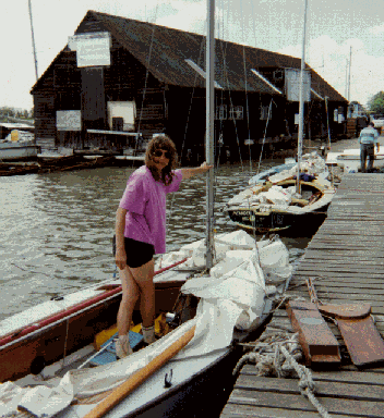
Unloading our boats back at Paglesham
Sunday: After a late breakfast we completed the last few miles to Paglesham, arriving at high water and tying up to the staging for convenience of unloading.